| Field | Entry | Comments |
|---|
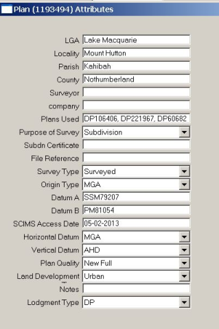
| LGA | | Set by user |
| Locality | | Set by user |
| Parish | | Set by user |
| County | | Set by user |
| Surveyor Name | | Set by user |
| Company | Optional | Set by user |
| Plans Used | | Set by user |
| Purpose of Survey | | Set by user |
| Subdivision Number | The number issued by the local council in the Subdivision Certificate | Set by user |
| File Reference | Surveyor's file reference | Set by user |
| Survey Type | | Set by user |
| Origin Type | | Set by user |
| Datum A | The survey Coordination mark name for the "A" point of the job datum | Set by user |
| Datum B | The survey Coordination mark name for the "B" point of the job datum | Set by user |
| SCIMS Date | Date SCIMS was accessed to get control data | Set by user |
| Horizontal Datum | | Set by user |
| Vertical Datum | | Set by user |
| Plan Quality | | Set by user |
| Land Development Type | | Set by user |
| Notes | Optional field for any special notes about the plan | Set by user |
| Lodgement | | Set by user |